
Accurate, Licensed Boundary Surveys Across Melbourne and Regional Victoria For Residential, Commercial and Development Projects
At T Cooper & Associates, we provide professional boundary re-establishment surveys and title re-establishment surveys in Melbourne and regional Victoria to determine the exact position of your property boundaries. Our licensed surveyors use precise measurement techniques to ensure you can build, fence or develop with confidence.
Whether you are building a new fence, planning an extension, or resolving a boundary dispute, an accurate boundary survey is essential before any construction works begin. They’re often most valuable during the planning stage, allowing proposed designs to consider any boundary discrepancies before construction begins.
What is a Boundary Survey?
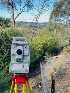
Surveyor completing a boundary re-establishment survey in Melbourne.
A boundary survey, title re-establishment survey, repeg survey or boundary re-marking survey are all terms commonly used to describe the process of re-establishing the legal boundaries of a property. A boundary re-establishment survey is the process of accurately locating and marking the boundaries of your property title and lodging a mandatory re-establishment (RE) plan or sketch to the Surveyor-General Victoria. Lodging the RE Plan/sketch makes it part of the official survey records used by the Land Registry and other surveyors. This Plan/sketch serves as the definitive record of how your boundaries were defined at a specific point in time.
A title re-establishment survey ensures you know exactly where your land begins and ends, based on official title information and field measurements. This removes uncertainty and provides clarity regarding the true position of your property boundaries.
Boundary surveys are commonly required for:
- New fencing
- Home extensions or renovations
- Building approvals
- Property boundary disputes
- Subdivision and development planning
When Do You Need a Boundary Re-Establishment Survey?
You should arrange a boundary survey if you are:
- Purchasing a property and want to ensure what you see is what you get
- Building or replacing a fence
- Constructing close to a boundary line
- Unsure of your exact property boundaries
- Experiencing a dispute with a neighbour
- Planning a subdivision or development
- Buying or developing in a new estate
In many cases, boundary uncertainty can lead to costly construction errors. Therefore a survey helps ensure you build in the correct location the first time.
Boundary Re-Establishment Surveys in New Residential Estates (Repeg Survey)
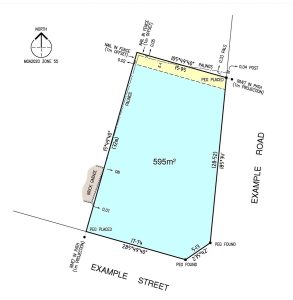
Repeg survey plan provided to our clients.
In many new residential estates across Melbourne and regional Victoria, boundary pegs can be missing, disturbed, or removed during construction works on adjoining land.
We provide repeg and boundary re-marking services to accurately re-establish your property boundaries where original survey marks are no longer visible.
This is especially important before:
- Building construction commences: builders often complete a site inspection prior to works commencing to verify existence of boundary pegs.
- Fencing installation
- Landscaping works
- Driveway construction
Our team works extensively in Melbourne’s suburbs and regional Victoria’s growth corridors and new estates to ensure boundaries are correctly reinstated before further works proceed.
Our Boundary Survey Process
Boundary re-establishment surveys require detailed investigation, precise field measurement, and careful analysis of historical survey information. Our process is designed to ensure your property boundaries are accurately defined and supported by reliable survey evidence.
1. Review of Title & Historical Survey Records
We obtain and review your Certificate of Title, plan of subdivision or title diagram, and surrounding survey records. In many cases, historical survey information from adjoining properties and previous cadastral surveys is also analysed to assist in accurately re-establishing boundary positions.
2. Site Inspection & Field Measurement
Our surveyors undertake a detailed site inspection and complete precise field measurements using modern surveying equipment and established survey control existing in your neighbourhood.
3. Boundary Analysis & Re-Establishment
Collected field data is carefully analysed, alongside historical title and survey information by our licensed cadastral surveyor to determine the legal position of the property boundaries in accordance with cadastral survey principles and Victorian survey standards.
4. Boundary Marking
Boundary marks or survey pegs are placed on-site to clearly identify the re-established boundary positions for construction, fencing, or future reference. Ideally the boundaries would be marked with a title peg at each corner of the property, but often the boundaries are marked with offset marks because existing fencing or features prevent us from placing marks on the exact title boundary.
5. Survey Documentation & Reporting
Upon completion, you will receive clear survey documentation suitable for builders, architects, fencing contractors, designers, or future property reference.
6. Lodgement with the Surveyor-General Victoria
For boundary or title re-establishment surveys, a mandatory re-establishment sketch or RE Plan is lodged with the Surveyor-General Victoria in accordance with survey regulations. This creates an official public record of how the property boundaries were defined at the time of survey, providing ongoing confidence and reference for future property owners, surveyors, and development works.
Areas We Service
We provide boundary surveys across all Melbourne and regional Victoria suburbs, including:
- Northern suburbs (Wollert, Donnybrook, Craigieburn, Mickleham, Beveridge, Wallan)
- Western suburbs (Tarneit, Truganina, Point Cook)
- Eastern suburbs (Doncaster, Ringwood, Mitcham)
- South-east growth areas (Clyde, Officer, Cranbourne)
- Ballarat (Alfredton, Miners Rest, Winter Valley, Lucas, Cardigan)
- Geelong & Surrounds (Armstrong Creek, Charlemont, Mount Duneed, Lara, Bannockburn, Fyansford, Leopold)
If your project is located anywhere in Melbourne or surrounding regions, we can assist.
How Much Does a Boundary Survey Cost in Melbourne and Regional Victoria?
The cost of a boundary or title re-establishment survey depends on several factors, including:
- Property size
- Site accessibility
- Location
- Complexity of existing boundaries
- Existing survey information surrounding your property
For an accurate quote, please contact our team with your property details.
Why Choose T Cooper & Associates?
- Licensed and experienced surveyors. Our licensed cadastral surveyor, Troy Cooper, is registered in Victoria and can be verified through the Surveyors Registration Board of Victoria.
- Accurate, reliable boundary identification
- Extensive experience across Melbourne and regional Victoria
- Strong knowledge of new estates, growth area developments and subdivisions
- Trusted by homeowners, builders, and developers
We focus on providing clear, practical surveying outcomes so you can move forward with your project confidently.
Book a Boundary Survey in Melbourne or Regional Victoria
T Cooper & Associates provides professional boundary and title re-establishment surveying services across Melbourne and regional Victoria, delivering accurate boundary definition supported by detailed cadastral investigation and reliable survey methodology.
From residential fencing projects through to large-scale development and subdivision works, our team is committed to providing clear, practical, and dependable surveying outcomes.
-
Is there a difference between a boundary survey, title re-establishment survey, repeg survey or boundary re-marking survey?
These terms are commonly used interchangeably within the surveying industry to describe the process of identifying, re-establishing, documenting, and marking property boundaries based on the legal title and available survey evidence.
A boundary survey or title re-establishment survey generally refers to a licensed cadastral survey used to accurately determine the legal position of property boundaries based on title information, historical survey records, and field measurements. The surveys being referenced by these names typically take place in older, more established suburbs, and require greater time and investigations due to the availability of recent survey information.
Repeg surveys and boundary re-marking services typically refer to the physical replacement or marking of boundary positions on-site, often where existing survey marks or boundary pegs have been disturbed or removed during construction or fencing works. These surveys generally occur in new housing developments. The availability of reliable and recent survey information in recent estates can reduce the time involved in these surveys, and are often less costly to re-establish than older titles.
While the terminology can vary between surveyors, or clients, the purpose is typically the same: to accurately determine the location of property boundaries and physically mark them on site using survey pegs, marks, or other boundary indicators.
-
How long does a boundary survey take?
Most residential boundary surveys are completed within a short timeframe depending on property size and conditions. Typically we spend some time in the office examining survey information, a day in the field collecting the data, then another back in the office analysing and computing information. Surveys typically take between one and two weeks from booking to report delivery.
-
Do I need a survey before building a fence?
Yes. A boundary survey is strongly recommended before constructing or replacing a fence to avoid encroaching on neighbouring land, and to ensure you occupy your full title.
-
What if my boundary pegs are missing?
This is common in new estates or after construction works. We can re-establish and re-mark your boundaries through a repeg survey.
-
Can boundary disputes be resolved with a survey?
Yes. A boundary survey provides legally based measurements that can help clarify property boundaries in disputes. It is the first document you will need if you have a conflict with a neighbour.
-
Can any surveyor complete a title re-establishment survey?
In Victoria, a title re-establishment survey must be completed by a licensed land surveyor qualified to undertake cadastral surveying work. These surveys involve the interpretation of title information, historical survey records, and legal boundary evidence to accurately determine the position of property boundaries.
Licensed surveyors are authorised to prepare and lodge re-establishment plans and survey documentation with the Surveyor-General Victoria in accordance with cadastral survey practice directives and surveying regulations.
Ready to confirm your property boundaries with expert precision? Contact us today for your free quote and experience reliable boundary survey services in Melbourne.